Starting from the valley station of the Uga-Express we drive in direction to "Walisgaden". At the "Walisgaden" the asphalt changes into a gravel road. Arrived at the "Vordere Uga Alpe" the path steeply goes down to the "Lauben Bach". From here the path goes up in direction to "Hindere and Mittlere Argenalpe". Right from the "Mittlere Argen Alpe" the descent beginns to the "Argenwald Alpe" an then to the road (L193). The road goes up to the valley station of the Uga-Express.
Damüls-Uga


Tour data:
- Distance: 15.2 km
- Ascent: 519 m a.s.l.
- Difficulty: difficult
Description
Waypoints on this tour:
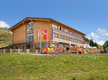
Elsenalpstube
Restaurant | After 3.8 km
Uga 103
6884 Damüls
Telefon: +43(5510)297
mail@elsenalpstube.at
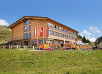
Elsenalpstube
Restaurant | After 3.8 km
Uga 103
6884 Damüls
Telefon: +43(5510)297
mail@elsenalpstube.at
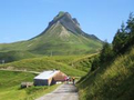
Mittagspitze
Observation point | After 4.2 km
Die Damülser Mittagspitze ist ein 2095 m ü. A. hoher Berg im Bregenzerwaldgebirge im österreichischen Bundesland Vorarlberg. Sie ist d...
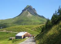
Mittagspitze
Observation point | After 4.2 km
Die Damülser Mittagspitze ist ein 2095 m ü. A. hoher Berg im Bregenzerwaldgebirge im österreichischen Bundesland Vorarlberg. Sie ist die höchste Erhebung der Gemeinde Damüls und Hauptgipfel der Damülszer Berge. Der ursprügliche Name dieses Berges lautet Trista.