0: 0,00 km / 1426 m: Start Serfaus church, towards village exit to the Parkcafe, towards Fiss1: 0,80 km / 1428 m: After the parking place near the Parkcafe you have to turn on the right and continuing straight ahead along the asphalt path, past the Fineshof2: 1,79 km / 1407 m: bike trail to Fiss3: 3,15 km / 1424 m: the second village entry of Fiss, after the Hotel Fisserhof, continuing on the left until the post office / town hall4: 3,41 km / 1437 m: post office / town hall easy left, then continuing on the right to the Kulturhaus5: 3,71 km / 1440 m: Kulturhaus Fiss, continuing straight ahead towards Ladis, past the chapel and continuing straight ahead, the next bifurcation continuing straight ahead (asphalt path)6: 4,87 km / 1408 m: asphalt path finish - gravel path begin, continuing straight ahead, direction board Ladis7: 5,53 km / 1321 m: bifurcation, gravel path finish - asphalt path begin, continuing on the right to Ladis8: 6,44 km / 1215 m: bifurcation on the left, continuing along the asphalt path (past the fire station)9: 6,61 km / 1205 m: town hall Ladis, down on the right, then continuing on the left along the asphalt path, past the church towards Hotel Bad Ladis10: 6,74 km / 1199 m: Hotel Bad Ladis, easy left, then continuing on the right until you arrive the pond11: 6,83 km / 1196 m: Lader pond, continuing on the left along the asphalt path, direction board Neuegg, Obladis12: 7,12 km / 1203 m: bifurcation continuing straight ahead along the asphalt path, direction board Neuegg, Obladis13: 7,72 km / 1276 m: bifurcation, continuing straight ahead along the asphalt path towards Neuegg, the next bifurcation continuing straight ahead towards Neuegg, Schöne Aussicht14: 8,36 km / 1330 m: bifurcation, continuing straight ahead towards Neuegg, Schöne Aussicht15: 9,33 km / 1438 m: on the right Café Neuegg, asphalt path finish - gravel path begin, continuing straight ahead16: 9,40 km / 1445 m: bifurcation, continuing on the left along the gravel path, direction board Schöne Aussicht, Schöngampalm17: 9,95 km / 1497 m: bifurcation, on the right side, viewing tower, continuing on the left along the gravel path towards Schöngampalm18: 11,01 km / 1597 m: bifurcation, uphill on the left along the gravel path towards Rabuschl/Fiss, the next bifurcation continuing straight ahead towards Rabuschl/Fiss19: 12,32 km / 1655 m: bifurcation, downhill on the left along the gravel path towards Fiss20: 14,45 km / 1621 m: Rabuschl, at the children’s playground uphill on the right along the gravel path, direction board Frommes, Windles, Frommesalm, the next bifurcation straight ahead21: 15,23 km / 1710 m: direction board Frommesalm, continuing straight ahead along the gravel path22: 15,67 km / 1746 m: bifurcation on the left, downhill along the gravel path to Frommesalp23: 15,88 km / 1735 m: Frommesalp24: 15,91 km / 1734 m: bifurcation, down on the right along the gravel path to Fiss25: 16,40 km / 1676 m: bifurcation straight ahead towards Fiss26: 17,08 km / 1584 m: bifurcation right, down the gravel path to Fiss27: 18,10 km / 1570 m: gravel path finish - asphalt path begin, continuing straight ahead to Fiss28: 18,47 km / 1455 m: Fiss - Restaurant Taolstock, asphalt path straight ahead to the post office / town hall29: 18,59 km / 1441 m: post office, continuing on the right along the asphalt path, by the Hotel Tirol uphill on the right until the Restaurant Dorfalm, there continuing straight ahead until the Schlosshotel (Laurschweg)30: 19,36 km / 1493 m: After the Schlosshotel, bifurcation, continuing sharp left along the gravel path, direction board Serfaus - forest road31: 20,10 km / 1507 m: bifurcation, down on the left along the single trail, direction board towards Serfaus32: 20,28 km / 1452 m: on the right over the meadow, direction board Serfaus, short trail, gravel path b
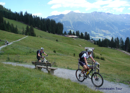
21 Frommesalp Tour
Tour data:
- Distance: 23.0 km
- Ascent: 578 m a.s.l.
- Difficulty: average
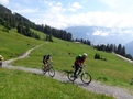
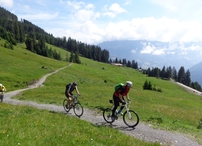
Description
Waypoints on this tour:
Others | After 4.4 km

Others | After 4.4 km
City/Village | After 6.9 km
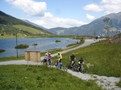
City/Village | After 6.9 km
Restaurant | After 15.8 km
Restaurant | After 15.8 km