1: 0,00 km / 1420 m: Start church towards village exit until parking area finish2: 0,78 km / 1425 m: finish parking area easy down on the right, direction board Finesweg, following Fiss, before the Fineshof easy on the left, following the new hiking- and bikeway (through the meadows) until the T-junction Serfauser Feld Straße3: 1,78 km / 1404 m: Serfauser Feldstraße, easy across uphill on the left, following direction board Fiss Radweg to Fiss4: 3,00 km / 1422 m: Fiss - after the Hotel Fisserhof left, the second village entry easy up until the town hall, RAIKA5: 3,20 km / 1436 m: RAIKA, town hall easy right, direction board Kulturhaus, following Untergasse until shortly before the Kulturhaus - bifurcation6: 3,50 km / 1436 m: bifurcation before the Kulturhaus up on the left, following direction board Latschthayaweg, past the Hotel Bergblick, uphill until house Pittl, crossroads, asphalt finish7: 3,74 km / 1462 m: crossroads, gravel path begin, easy right, continuing following direction board Obladis8: 5,14 km / 1475 m: Kolbenstein (crossroads) easy left, continuing following direction board nr. 3 Obladis until Falterjöchl (enjoy the viewing point)9: 5,57 km / 1490 m: down the Falterjöchl, following direction board nr. 3 Obladis until the next crossroads10: 5,96 km / 1453 m: crossroads, down straight ahead, following direction board nr. 3 Obladis (attention: short steep part) until the Villa11: 6,25 km / 1405 m: Villa easy left, broad forest road, continuing past the Wassertor12: 6,67 km / 1401 m: bifurcation easy left, following direction board Cafe Obladis (Karrenweg)13: 7,00 km / 1399 m: Cafe Obladis - snack-bar with mineral and sulfur spring14: 8,39 km / 1399 m: Cafe Obladis, broad gravel path, easy downhill to the right-hand bend, following direction board Ladis road (attention: car traffic) and left-hand bend, continuing down along the asphalt path to Ladis village pond15: 8,17 km / 1322 m: crossroads, sharp down on the right, direction board Ladis, asphalt16: 9,85 km / 1176 m: castel pond, a place to stay, right, flat, easy up past the church, along the street easy uphill, direction board Dorfstraße until Sonnenbahn station at the bottom17: 10,65 km / 1220 m: Sonnenbahn station at the bottom to Fiss village (don’t exit at the middle station), from the Sonnenbahn station easy down on the right, on the road to Serfaus, back along the bikeway to Serfaus18: 14,15 km / 1420 m: finish Serfaus
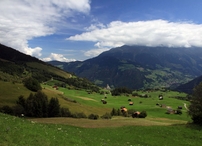
12 Family and pleasure tour Obladis
Tour data:
- Distance: 16.5 km
- Ascent: 393 m a.s.l.
- Difficulty: easy
Description
Waypoints on this tour:

Seeing | After 7.0 km
Seeing | After 7.0 km
lift station | After 10.4 km
lift station | After 10.4 km